- EXPERT'S HELP
- +256789210067
- +256200955001
- info@kenlinktours.com

What to expect on a game drive in Africa.
August 29, 2023
National parks in Uganda. Uganda has 10 national parks, that are scattered is different parts of the country, and they vary on the specific activities. Uganda is a home for a number of animals, birds, beautiful landscapes, beautiful culture and others. With these 10 national parks, there are a number of wildlife, and activities done. For example, you may love to do Gorilla Trekking Safari, you can visit Bwindi Impenetrable Forest National Park and Mgahinga Gorilla National Park all located in south western Uganda.
Uganda has a number of wildlife including the big five mammals, that include the Lions, Elephants, Buffaloes, Leopards, and these can be seen in Queen Elizabeth National Park, Kidepo Valley National Park, Murchison Falls National Park, and Rhinos that can be seen from Ziwa Rhino Sanctuary located in Nakasongola.
You may be planning for a mountain climbing/hiking, then you may plan your trip to Mount Rwenzori National Park, Elgon National Park and Mount Muhavura. You can also see other animals in the above national parks, or others nationals parks as mentioned in the information below.
- Bwindi Gorilla National Park
Background and location
Bwindi Gorilla National Park was gazette in 1991 and turn in to a UNESCO world heritage site in 1994 to protect the rear and endangered mountain gorillas. Located in south-western Uganda at the junction of the plain and mountain forest, covers 32000 ha and is known for its exceptional biodiversity, with more than 160 species of trees and over 100 species of ferns, many types of birds and butterflies can also be found there. The unique indigenous typical culture of the Batwa with their traditions as they are the original inhabitants of the place and the forest.
Location. Kanungu district Uganda
Size. 331km
Established. 1991
Attractions and activities
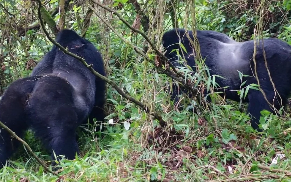
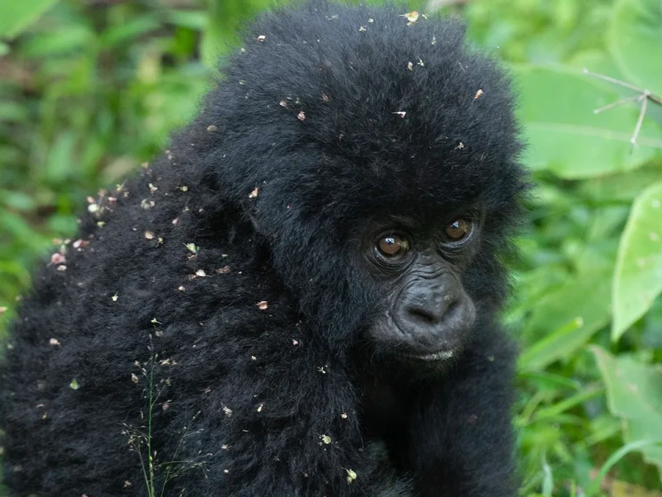
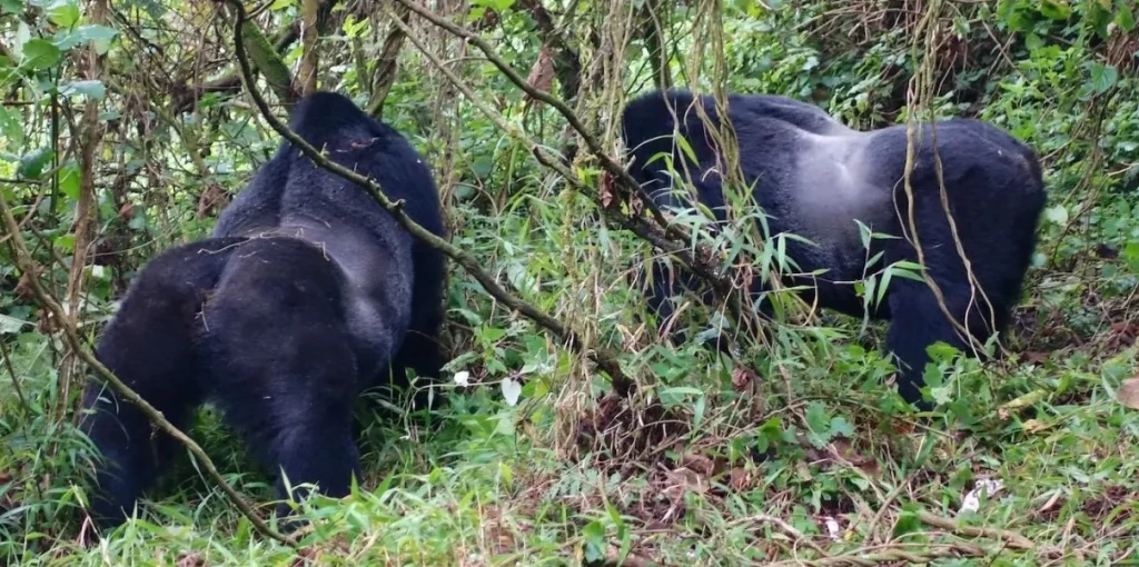
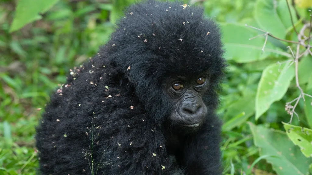
Mountain gorillas and gorilla trek. There are over 800 mountain gorillas in Bwindi with 21 groups habituated for tracking that are distributed in four sectors of buhoma, ruhijja, nkuringo and rushaga. Note only 8 people are allowed to visit the gorilla family for trek and one hour is being given to that particular group and the person must be 15 years and above. Visitors are advice to book gorilla permits in advance prior to the tracking.
Munyange water fall nature walk and hiking. This forest trail start right from buhoma along the river ivi-nkuringo and the hike continue to the sensational falls, birds life and the cool breeze there is rewarding around the falls.
Muzabajirro loop. The muzabajirro loop is a 6km walk around a hill you will led by the UWA guide through the trail and come up with great sights of primates, birds and a gainful view of the virungas.
The ivi river walk. This raises 14km and takes around 7 hours using a trail pass in a place known as mukempunu which ,means a place of pigs where wild pigs can be encountered
The habinyanja trail. This trail attracts a lot through offering many species but like takes 4-6 hours to access it in both descending and ascending. The trail takes you in the stunning ascents of the habigorogoro and riyovi ridge where you will be able to see Buhoma River.
The buhoma-nkuringo trail. The buhoma trail can take three or four hour, crossing through the park and adjoining the two villages and offering spectacular views of the misty hillsides as you ascend the hills towards nkuringo or else it led you to ivi river walk for more reward able views.
Birds watching. Home to over 350 birds species are recorded, including 23 endemics such as short-tailed warbler and blue-headed sunbird plus the seven IUCN red data listed species. Some of the birds includes the blue flycatchers and red-headed bluebill, African emerald cuckoo, common bulbul among others.
Cycling/mountain biking. This can be carried right from the mountain trail from the park headquarter along buhoma to the ivi river. The trails make up 13km providing you with great looks of wildlife like bushbucks, black and white colobus and red tailed monkeys among others.
Accessibility.
By road;
From kampala the major capital city to ruhijja, rushaga, nkuringo and buhoma the major the trail head from queen Elizabeth about 9 hours drive on a 4WD safari car recommended. Approximately 499km
By air;
Chartered flight can be organized from Entebbe airport or kajjansi air strip to kihihi air field and get transferred to the sectors about 1.30h flight.
What to carry
They include; rubber walking boots for hiking, warm clothes, sun screen, sun hat, water proof bags, enough mineral water and snacks among others
Where to stay/accommodation.
This range from luxury, mid range, and budget but we advise you to book the accommodation from the sector you are tracking from. Some of the accommodation includes; nkuringo Bwindi gorilla lodge, gorilla heights lodge, ruhijja gorilla lodge, Bwindi forest lodge, ichumbi gorilla lodge, lake mulehe gorilla lodge, silverback lodge among others.
2. Mgahinga Gorilla National Park.

Background and location.
Mgahinga gorilla national park was established in 1991 to protect the endangered mountain gorillas and the golden monkey. This is the smallest national park in Uganda with a total area of 37km but yet with a rare remarkable species compare to other conservation are in the world. It lie in the southwestern coner of kisoro district bordering DRC and Rwanda along the virunga ranges of mount muhabura, mount Gahinga and sabinyo forming three national parks of volcanoes from Rwanda and virubga from DRC. The original inhabitants of the forest are the Batwa pigmy people.
Location; Kisoro district
Size; 37km
Established; 1991
Distance; 484km
Attractions/activities.
Mountain gorillas/gorilla tracking. Mgahinga have got one gorilla family known as the nyakagezi group led by the dominated male called mark. Gorilla tracking here is both the mixer of mountain climbing and nature walk along the Gahinga slope. On your way you will experience many birds’ species, other primates and the bamboo vegetations and en-route to the community walk on your way back. Hiking sticks is required and potters were necessary to carry your luggage.
Virunga volcanoes hike. Mgahinga is one of the most scenic given that the park lies on the northern slopes of mt. muhabura (4127m), mgahinga (3474m) and sabinyo (366m) means old man’s teeth. These three volcanoes create an unforgettable regional backdrop. Mgahinga also offers plat form view of the neighboring countries of Rwanda, DRC in which they can be view at a point.
Golden monkey tracking. Golden monkey tracking is one of the top activities that make this park an interesting place for the tourists to visit for primate safari. It is only in this park where mountain gorillas and golden monkeys can be track with the slogan where gold meet silver. Challenge yourself by hiking along the virunga ranges and the bamboo vegetables.
Ngarama cave exploration. The 342m long Ngarama cave lies beneath a plateau northern edge of the park, 3km from Ntebeko. It is set in the former farmland zone but in earlier times, the cave forest when it was occupied periodically by the Batwa who used it as a council chamber and a retreat.
Bird watching. Mgahinga gorilla national park is ideal for birding, bird through different places including the buffalo wall, forests, wetlands and other habitats. Some of the birds to see includes ibis, speckled mouse, fire finch and many others found in the area.
Batwa trail. The Batwa trail leads from the base of muhavura cave. This walk is conducted by Batwa guides who provide insights in to their traditional forest life and culture. The Batwa used to live with the gorillas in harmony within the mgahinga forests.
Border to Boarder Trail. Also around the town of kisoro, one can do visit the two neighboring boarder of Kyanika to Rwanda and Bunagana border to DRC.
Accessibility/getting there
By road;
From Kampala the capital of Uganda to kisoro district via Mbarara-Kabale to Ntebeko gate about 489km 9-10 hours drive with a number of stopovers for photography, meals, snacks.
Also from Kigali to kisoro via Burare-Kyanika to Ntebeko about 4 hours drive
By air;
From Entebbe airport or Kajjansi air strip to kisoro Airfield using chartered flight about 1:30 hours flight then you get transferred to the park about 14km from kisoro airstrip to Ntebeko main trail head entering Mgahinga Gorilla National Park.
Where to stay.
There are several options on where to stay around the park since there is no accommodation inside, there are camping sites, hotels, guest houses, and lodges of luxury, mid-range and budget. For expel; mount gahinga lodge, travelers rest kisoro, lake mutanda resort, lake chaifi resort, muhabura view guest house, kisoro tourists hotel among others.
When to visit.
Mgahinga gorilla national park can be visited any time and month in a year through out since it is not affected by the weather and the nature of the activities done is supported annually. Gorilla permits and the golden monkey permit is required to be obtained earlier before travelling.
3. Queen Elizabeth National Park.

Background
Queen Elizabeth national park is understandably Uganda’s most popular tourists’ destination. The park diverse ecosystems, which include sprawling savanna, shady, humid forests, sparkling lakes and fertile wetlands makes it the ideal habitat for classic big game, ten primates species including chimpanzees and over 600species of birds. Set along the kazinga channel with its banks lined with hippos, buffalos, crocodiles and endless ishasha plains whose fig trees hide lions ready to pounce on herds of unsuspecting Uganda kob.
Location; kasese, rubirizi district in western Uganda
Size; 1978km
Established; 1952
Distance; 400km
Attractions/activities
Game drives;
A). Kasenyi plain. Half an hours’ drive from mweya, the open grasslands of kasenyi provide the primary game viewing area in central queen Elizabeth, herds of Uganda kob and the lions that prey on them. Kasenyis experienced ranger guides can usually locate lions.
A). Ishasha. Conveniently located on the road to Bwindi, queen Elizabeth southernmost sector offers a classic game viewing experience under vast rift valley skies. Expect to see buffaloes, hippos, elephants, topis beside, chance of sighting lions is popular good in ishasha; the local pride obligally spend their days resting up in the branches of shady fig trees.
Forest walk;
A). Kyambura gorge. The forest-filled kyambura gorge extends from the kichwamba escarpment to the kazinga channel. Enjoy the giddy viewpoint on the edge of the 100m-deep chasm before descending into the depths to track chimpanzees with UWA guides.
B). Maramagambo forest. At the foot of the kichwamba escarpment, the shady maramagambo forest contrasts with the parks open grasslands, guided walks afford sightings of primates and rare birds.
Mweya peninsula and kazinga channel. Queen Elizabeth main tourism hub is found in mweya peninsula, 22km west of the kasese-mbarara road. Mweya which occupies an elevated plateau overlooking the kazinga channel and lake Edward, is the sight of the high market lodge. On the kazinga channel, there is launch trip cruise for buffalos, crocodiles, elephants among others
Crater drive. Dozens of volcanic craters pock the landscape north of mweya to remind us of the Albertine rifts violent tectonic history. The 27km crater drive between the kabatoro and crater gates follows a breathtaking route around the rims of extinct craters filled, variously with lakes, forest and grassland. The queens’ pavilion at the crater gate on the eastern edge of the crater area, has been visited three times by British royalty. A small information center and coffee shop stands on the site. The equator makers straddling the adjacent kasese highway provide a popular photo opportunity.
Katwe salt lake. The people of katwe town, 12km from mweya have been extracting salt from the saline lake katwe using evaporations pans since the 14th century, the local guide will escorts visitors down in to the crater to see the process. The adjacent lake munyanyange is rich in water birds including migrating lesser flamingo between august and November.
Kyambura wildlife reserve. This small reserve to the east of kyambura gorge is dotted with crater lakes that are visited, seasonally by greater and lesser f;amingo.
Katara women elevation group and the kichamba culture; community. This is also one of the connecting activities around queen Elizabeth. It offers women art works like baskets, and also traditional dance around the twin lake.
Accessibility/getting there.
By road;
Two routes run from kampala to mweya, the primary tourism hub in QENP, the most scenic route passes through fort portal (410km) and offers detours to kibale, Semuliki and rwenzori mountains national parks. The alternative (420km) runs through mbarara and Bushenyi and passes lake mburo national park
QENP southerly ishasha sector is directly on the main route to/from from buhoma, the main mountain gorilla tracking trail head in Bwindi which lies 62km south.
By air;
From Entebbe airport or kajjansi airstrip to kihihi airfield using arranged charter flight.
Where to stay
A range of accommodation in and around the park craters for up-market, mid range, budget and self-catering visitors. At mweya, UWA offers 4-5 bed room bungalows equipped with cooking facilities and utensils others includes jacana lodge, mweya safari lodge, ishasha wilderness camp, irungu forest safari ;lodge, kazinga resort, buffalo lodge etc.
4. Murchison Falls National Park

Background.
Murchison falls national park was the first national park to be gazettes and it is the biggest conservation area in Uganda. It sits on the shore of lake Albert, in northwestern Uganda. Its known for Murchison falls, where the Victoria Nile river surges through a narrow gap over a massive drop. Park wildlife includes elephant, lions, leopards, buffaloes and the adjacent rhinos at the ziwa sanctuary making it the big five national park in Uganda.
Location; kiryandongo, pakwach, nwoya district
Size; 3840km
Distance; 305km to paraa
Established; 1952
Chimpanzee tracking in budongo. Budongo forest is an excellent area for chimps tracking, during the off season, you can even do an all day chimps habituation and requires a few hours walk along the trail.
Boomu womens group. Boomu village is a cultural experience near the Murchison falls, they provide traditional dance, cousins, from their local gardens to the instruments group who normally welcome you.
Boat cruise along the river Nile. There is nothing more enjoyable than sunset cruise and lunch trip to the bottom of the Murchison falls blessed with games like buffaloes, hippos, crocodiles and the bee eaters at the nyamusika cliff.
Nature walk. Nature walk can be done from the top of the falls to the bottom through bakers trail. It is rewarding with primates, birds species etc.
Game drive. Gamdrive can be done from paraa via pakuba up to hippo pool plain for refreshment with snacks; animals like lions, elephants, hart beast, giraffes can be viewed.
Bird watching. Murchison falls has over 350 birds species which are everywhere for sighting for example Abyssinian ground horn bill, king fisher, shoe bill stork among others ,making birding safari rewarding.
Sport fishing. The Nile has many species of fish including the nile pierce, tilapia could be fished on the boat and it can weigh up to 400kg.
Accessibility/ getting there
By road;
From kampala to paraa via masindi kichumbanyobo gate (305km), via karuma CHOBE GATE, via olwiyo wankwar gate, via pakwach tangi gate, via bulisa mubako gate, via masindi bugungu gate
By air;
From kajasi airstrip to chobe airstrip, and pakuba airstrip.
Where to stay
Paraa safari lodge, chobe safari lodge, fort murchison lodge, red chilli, leosin hotel, gipir and labongo lodge, etc.
When to visit
The best time to visit is during the dry seasons from December to late februray and from june to September when animals are concentrated around water points. The prime time for bird watching is January-march when tourist numbers are lowest..
5. Kibale Forest National Park

This is one national parks in uganda and largely forest park is best known for its number and variety of primates, which include Uganda’s largest population of chimpanzees. Kibale is one of the Africa’s foremost research center for tropical forest biology. East of rwenzori, the land is dotted with volcanic crater lakes and carpeted with tea plantations and tropical forest. The largest track of forest is protected within 795km. it has got 350 tree species, 71 mammals, and 170 birds species, over 13 species of primates including the localized red colobus monkey and L’Heost monkey.
Location; fort portal, kamwenge district
Size; 795km
Established; 1993
Distance; 315km
Activities/attractions
Primate walks (chimpanzee tracking). The perennially popular primate walk provides the chance to observe chimpanzees in their natural habitat. Kanyanchu groups are accustomed to human presence some have been observed for over 25 years and the chance of locating them is 90%.
Chimpanzee habituation experience. This enables visitors to accompany researchers and habituations in to the forest, the chimpanzee groups involved are less accustomed to human presence than those visited on the primate walk and following and viewing them is both exciting and challenging.
Nature walks. A nature walk is an opportunity to enjoy one of east Africa’s most beautiful and varied forests without pressure to locate chimpanzees or tick off a dozen kibale specials on the bird list. This is also an activities ideal for young visitors who are unable to accompany relatives on the primate walk. 2 hours nature walk begins from kanyunychu tourists center.
Birding. A bird lists of 372 forest, grassland and swamp species, including local endemics and central Africa specials make kibale a popular destination for birders. Forest birds can be sought, with the help of experienced UWA guides, on the forest trails at kanyanchu and sebitoli tourism sites.
Bigodi community walk. This is one of the best community trail in Uganda. Located just 5km from kuyuncyu. This wetland provides bird sightings like blue turaco, other antelopes are also found here too.
Accessibility/getting there
By road;
The main tourism hub at kanyanchu, on newly tarmac fort portal-ibanda road, can be reached from kampala by a numbers of routes all on surfaced roads. The most direct (335km) is via fort portal
By air;
Kibale has access to two airstrips; nyakisharara, near mbarara (100km on tarmac) and kasese (60km on surfaced and dirt road)
When to visit
The park can be visited any time of the year but be prepared for afternoon rain during the wet month.
Where to stay
Kyaninga lodge, kibale forest lodge, rwetera safari park, chimpundu lodge, ndali lodge, crystal safari lodge and also UWA camping site around sebitoli.
6. Kidepo Valley National Park
Background .
Kidepo valley national park was gazette in 1962 covering the total area of 1442km between 914m and 2750m above sea level. Bordering Kenya and south Sudan. Kidepo is the most isolated park lie in the north eastern corner in the district of karenga where the narus valley bisected to the no man’s land of the karamojong and the ik people settle.
Location; karenga district
Size; 1442km
Esblished; 1962
Distance; 570km
Attractions and activities
Narus valley game drive. The narus valley south of apoka is the parks prime game viewing area as wildlife congregates here for much of the year. Look for buffalo in the swamps along the valley floor, giraffe on the drier slopes above and scan the rocky outcrops for lions, in addition to the main gamecirciuts at kakine, katurum and nagusokopire, nearly created loops to the north west of apoka and to the south of the seasonal crocodile pool hav opened up new parts of the valley to exploration.
Apoka view points. Binocular viewpoints have been installed at apoka rest camp, nagusokopire campsite, and kakine campsite. The latter enjoys a superb 3600 panorama that includes the napore-nyungea range, the morungule mountains and mount lomej in south sudan.
Nature walks. Short nature walks around Apoka rest camp provide the chance to view species such as zebras, hart beast and reedbucks. Longer walks through the open grasslands of east kakine should provide sightings of giraffes, buffalo, elephants and perhaps distance lions. Visitors can also explore part or all of the 15km rionomoe trail on the southern side of the narus valley. All walks requires a ranger.
Bird watching. Experienced ranger guides are available at apoka to help locate and identify birdlife in the parks various habitats. E.g. lover birds, common bulbul, karamojong apallis
Mouyntain hiking. The morungole range, which rises from the plains to the north east of apoka, can be explored on foot with a ranger guide escort.
Community walk. Community walks provide the opportunity to learn about life in the local karajong manyattas (homesteads)at kawalakol, lorukul and karenga. And also ik people.
Sport hunting. This activity is done normally involving hunting and killing the animal agreed upon the paid ticket to kill by the UWA.
Accessibility
By road;
661km via moroto and mbale to nataba gate.
700km via soroti to nataba gate.
571km via gulu and kitgum to karenga to lokumiot gate
By air;
Charter and scheduled flights fly to kidepo airstrip (apoka) from kajjansi and or Entebbe airport.
Where to stay;
Apoka safari lodge, nga moru and kidepo savannah lodge, apoka bandas, maraa safari lodge, adere safari lodge among others.
When to visit
The park can best be visited in dry month when the rain is scarce especially from December to February and june to September.
7. Lake Mburo National Park.
Background.
Lake mburo national one of the 10 national parks in uganda and is Uganda’s smallest savannah park and the closest to both kampala and Entebbe. Lake mburo national park lie in the western region of Uganda in kiruhura district bordered with other districts including isingiro, and mbarara district. The park is home to animals like zebras, impalas, among others with over 68 species of mammal, rocks, forest vegetation, savannah grassland and 6 species of fish. 20% of the park is covered with the wetland system which is mark in the ramsar map forming the park of nakivali wetland system too. It does not have elephants and the lions.
Location; kiruhura district
Size; 370km
Established; 1993
Distance; 240km
Attractions/activities
Lake mburo boat trip. The eastern shore of lake mburo can be explored by boat, departing from a jetty at the lakeside campsite near rwonyo rest camp watch out for crocodiles and hippopotamus during the two hours voyage. You can also sight variety of birds including pelicans, herons and fish eagle and perhaps the rear fin foot and shoebill. Fishermen with their own equipment may fish in the lake from the campsite by arrangement.
Game drive. A new network of game drive tracks explores the eastern hinterland of lake mburo, providing the chance to see a variety of savannah animals and birds.
Salt lick walk. Guided walks explore the park around rwonyo, culminating in a visit to a natural salt lake where wildlife can be viewed from a timber observation platform.
Forest walk. This small tract of forest on the western side of lake mburo is home to a variety of forest bird species. Rubanga can be explored with a ranger guide.
Horseback safari. The grassy ridges in the eastern part of lake mburo can be explored on horseback. This activity is operated by mihingo lodge.
Mountain biking. Rwakobo rock and leopard tail rest camp both operate mountain biking trips in to the national park at nshara gate.
Viewpoints. South of rwonyo, the lakeside track climbs onto kigarama hill which provides a panoramic view of lake mburo. This lake and seven more can be seen from the equally dramatic kazuma lookout which lies at the top of a rather steep track accessed from the ruroko track near the kazuma/research track junction.
Birding. Prime areas for birding in lake mburo include the acacia woodland along the acacia and research tracks; the wooded shores of lake mburo as seen from the rwonyo launch (ideal territory for African fin foot) and the lakes northern fringe of papyrus wetland.
Village visit. Most of the lodges in and around the park provide the opportunity to visit a local homestead and learn about the traditional Banyankole life.
Accessibility
By road;
From kampala via masaka, lyantondwe to nshara gate about 228km, also to sanga gate .
By air;
From kajjasi or Entebbe to mbarara airstrip about 30km drive to the gate of sanga.
Where to stay
Mihingo lodge, rwokobo rock, eagle nest lodge, arcadia cottages, rwonyo rest camp among others.
When to visit
Lake mburo national park can be visited anytime throughout the year
8. Semuliki Sempaya National Park.
Backgrpund.
Semuliki national park sprawls across the floor of the semuliki valley on the remote, western side of the rwenzori. The park is dominated by the easternmost extension of the great Ituri forest of the Congo basin. This is one of Africa’s most ancient and bio-diverse forest; one of the few to survive the last ice age 12-18000 years ago. Semuliki valley contains numerous features associated with central rather than eastern Africa. With 441 birds species it is describe as the true birders haven. Borders Congo with river Semuliki forming the hot springs of male and female hot spring where eggs can be boiled just few minutes which shows how hot the water could be.
Location; Bundibugyo
Size; 219km
Established; 1993
Distance; 381km
Attractions/activities
Bird watching experience. Semuliki is a birds haven which is known for a lot of birds species including the spot breasted ibis, heartlaud duck, chestnut-flanked goshawk, red-thighted sparrawhawk, turaco among others. They can be viewed on the nature walk trail with the experienced guide.
Game drive in tooro Semuliki reserve. That could be more adventurous and magical than wildlife viewing in an African natural park. there are three trucks which cross the savannah grassland where you can spot animals like forest elephants, leopards, bush babies, buffaloes, Uganda kob among others.
Cultural and community encounter. The Batwa hunter-gathers who are dependent on Semuliki forest for food, shelter, medicine and tools, will be entertained as they display their rich cultural history through music and dance performances at ntandi.
Nature and forest walk. You can set off with your love one in the company of the guide for a 13km kirumia nature walk trail which runs through the heart of the forest to the semuliki river. You can as well have a forest walk for 11km red monkey truck that follows the parks eastern border which has the rare debrazzas monkey to the semiliki river.
Eggs boiling experience. Also boiling eggs at the hot water is one of the remarkable activities here, eggs can be boiled of only 12minutes and its ready you will enjoy your amazing sighting of the steam coming from the water which is extremely hot.
Visit amabere ga nyinamwiru cave. This is around the park en-route activity one can engage in. this cave have both historical stories, culture and the geographical findings of the ancient hard rock that was exposed to weathering and later left a deep hold in a cave to form a cultural site of the bukuku and the tooro strange story that it is in shape of the woman’s breast.
Accessibility
By road;
From Kampala via mityana-mubende-fort portal to bundibugyo 381km to sempaya gate
Also from kampala via mbarara-bushenyi-kasese-fort portal to bundibugyo 450km to sempaya
Where to stay
Semuliki safari lodge, UWA bandas and cottages, nyati game loge, hotel vanilla, Semuliki river camp among others.
When to visit.
The park can be tour any time and any month in a year.
9. Mount Rwenzori National Park.
Background.
The rwenzori mountain is one of the to national parks in uganda and consist of 6 distinct mountains, Stanley (5109m), speke (4890m), baker (4843m), emin (4797m), Gessi (4715m) and savioa (4627m). Mt stanleys 5109m margherita peak is the third highest point in Africa. The rewnzori was named as the mountain of the moon by the alexandrine geographer Ptolemy in AD 150. The explorer henry Stanley placed the rwenzori on the modern map on the 12th may 1888. He labeled it as rwenzori which means rain maker or cloud king. The oldest person to reach the peak of rewnzori aged 78 years. There is the snow at the top and this explains partly why river Nile and lake Victoria have water volume which is supplied by the ice melt current from the mountain. It is also a UNESCO world heritage site labeled in 1994.
Location; kasese district
Size; 995km
Established; 1991
Distance; 335km
Attraction/activities
Mountain trekking. Three routes ascend on to the high rwenzori. Rwenzori trekking service (RTS) operates the kilembe trail which enables nine days expeditions to the summit mount Stanley and a shorter, six days option to the more accessible, but equally scenic, mt luigi da savioa. The nyakilengija-based rwenzori mountaineering services runs the central circuit whichj reaches and returns from the mount stantley in seven days. The bukurungu trail ascends from kitumba to mount gessi.
Peak climbing. The highest peaks on the six mountains that form the high rwenzori can all be climbed. The most popular is the 5109m margherita, the highest point on mount Stanley and the roof of the rwenzori. Be awear the summiting on Stanley, speke, and baker is a physically demanding activity, frequently in bad weather, and for which specialist equipment and technical experience is required. An ascent of mount Stanley requires a minimum of seven days on the mountain.
Hiking. The real appeal of the rwenzori lies, not in the joy of reaching the top, but in the opportunity to hike through superb mountains scenery by equatorial snow and outlandish vegetation. The kazingo trail enables a day-long transverse of the north rwenzori ridge between the fort portal plateau snd bundibugyo town in the semiliki valley on the west side of the mountain.
Birding. With 217 birds species, this involve endemic species of 17 species making rwenzori important bird area ( IBA) this includes; rwenzori turaco, blue headed sun bird, handsome francolin, among others.
Community walk and visit. The bukonzo culture around the mountain gives you the best of their culture. Around the park you will encounter cultural performance and traditions of the bakonzo in kasese.
Accessibility.
By road;
From Kampala via mbarara-bushenyi-kasese to ruboni trail head 335km
Also from Kampala via mityana-mubende-fort portal- kasese to nyakilengija trail head
By air;
From kajjansi or Entebbe to kasese airstrip and get transferred to the park headquarters.
Where to stay.
During hiking or trekking, the rwenzori mountaineering service provide camping along the peaks, UWA concessionaire operates provide accommodation in basic shelters on the kilembe and central circuit routes. These are provided with the wooden sleeping platforms/bunks and climbers should bring their own sleeping bag and camping mat. Kilembe trailhead.
When to visit.
The rwenzori can best climb during the drier months of January and june-july.
10. Mount Elgon National Park
Background.
Mount elgon was once Africa’s highest mountain, far exceeding kilimanjaros current 5895m. Millennia of erosion have reduced its height to 4321m, relegating it to the 4th highest peak in east Africa and 8th on the continent. Elgon is home to two tribes, the bagisu and the sabinya, with marginalized ndorobos. It has the world’s largest caldera and volcanic base located in Uganda-kenyaborder home to over 300 bird’s species including lammergeyer. Also the highest peak is known as the wagagai with sipi falls around the park making this place one of the best tourist site in east Africa.
Location; Uganda and Kenya
Size; 1279km
Established; 1992
Distance; 226km
Attractions/activities
Birding. The forest exploration center at kapkwai is an excellent birding site where tourists have many opportunities of watching the birds. This includes African blue fly catcher, African goshawk, black kite and black colored appallis among others.
Cultural encounter. The encounter come with the pride of meeting the sipi widows group that take visitors for a guided nature walk passing through the coffee plantation. Cultural encounters of the sebiny locals activities like weaving, cuisines and also the bagisu culture is amazing.
Budadiri community walks eco tourism experience. The community provides cultural dance, accommodations, guided coffee tours accompanied with the nature walk among others on your visit.
Mountain hiking and biking. The mountain biking trail runs from sipi trading center to chema hill in kapchorwa town. Routs are both up hill and downhill which enable some physical fitness for 1 hour ride.
Mountain climbing. It is easier to access throughout the year, lest congested and has many of the same attractions. The sasa trail is the shortest trail but toughest routes to the peaks, the round trip take 4 days and start from budadiri town. Explore the bamasaba on the way to wagagai peak along the lobelia and shrubs vegetation.
Nature walk. A full day hike leads from budadiri to the mudange cliffs, known as the wall of death, at sipi falls guides from the local community can organize walks of a few hours up to full day around local view point
Accessibility.
By road;
From Kampala via iganga-mbale-kapchorwa to budadiri 226km
By air;
From kajjansi or Entebbe to mable air strip then get transferred to the park.
Where to stay.
Mbale resort, sipi river lodge, noahs ark hotel, mount elgon hotel, rafiki lodge sipi,wagagai hotel, sipi valley resort, ccasa del turista, crown suites hotel mbale, fredsons hotel mbale, home of friends mount elgon, masha hotel, kapkwai cottages, among others.
When to visit.
June to august and from December to march although it can rain anytime.
